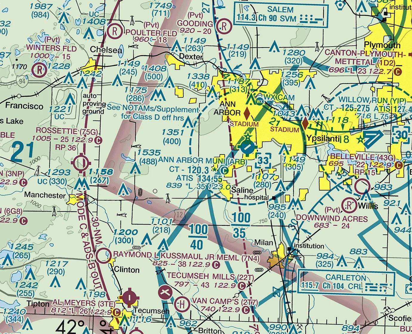
FAA Detroit sectional, 29 OCT 2026 edition. For briefing, not for navigation: fly from the current chart. Tap the chart to open it full size.
Today's flight
Could you fly to Battle Creek (KBTL) tomorrow? Not "could the airplane", but could you say yes with reasons, and know what would make you say no? That is the question for these two sessions.
The trip is your first real cross-country: KARB to KBTL and back, dual, on the next good day. You plan it as if you were going alone, because soon you will, and it is the same planning you will use someday for the trip you named in lesson 2. Session one builds the route: the airspace, the checkpoints, the navigation log and the flight plan. Session two is the weather and the decision.
You check the weather twice: the day before, to decide whether the trip is likely, and the morning of, to decide whether to go. Both times you say go or no-go out loud, with your reasons, and both times "no-go" is a good answer.
Every flight
Before every flight
P
Pilot.Am I fit to fly today? IMSAFE:
Illness
Medication
Stress
Alcohol
Fatigue
Emotion, and eating
A
Aircraft.Is this airplane ready, and right for today? Documents, inspections and open squawks; fuel and oil on board; weight, balance and performance for today's load.
V
Environment.What will today's flight meet? NWKRAFT, what 14 CFR 91.103 asks you to know before every flight, then the airspace and the route:
NOTAMs and TFRs
Weather, against your minimums
Known ATC delays
Runway lengths
Alternates
Fuel required, with reserve
Takeoff and landing distances
Airspace: the Class B limits from the current chart
The trip: heading, time, landmarks, wind and runway
E
External pressures.What is pushing me to go today: a passenger, a schedule, a plan I don't want to cancel? Would I go without it?
If it goes wrong.The takeoff emergency brief, out loud: an engine problem on the runway, after liftoff with runway left, and after liftoff without.
Who flies.Who does what today, and how we hand the controls back and forth.
Who runs it today:You, for the planned trip, as if leaving tomorrow morning. You brief me on the whole routine.
Deeper today:Weather, NOTAMs and TFRs, Airspace and The trip, at full cross-country depth, and Pilot through the hazardous attitudes. Weather becomes a full briefing for the route and both fields. NOTAMs and TFRs cover KARB, KBTL and everything along the way. Airspace is a limits block for the whole route. The trip becomes a complete navigation log with checkpoints, fuel and a plan B.
Recall
From earlier lessons
The haze closes in and the horizon goes. What do you do first?
Reveal answer
Eyes to the attitude indicator, wings level, then a gentle turn back toward where the weather was good, and call ATC.
In a METAR, what do the visibility and the ceiling look like, and what is a ceiling?
Reveal answer
Visibility is in statute miles (like 6SM). The ceiling is the lowest broken (BKN) or overcast (OVC) layer, in hundreds of feet above the ground.
On the triangle, how did you set your maximum altitude for each leg?
Reveal answer
From the Class B floors over that leg on the current chart, with a margin below the lowest one.
Why do you look at the temperature for your departure time when you plan a takeoff?
Reveal answer
Because density altitude, and with it the takeoff and climb performance, depends on the temperature when you actually go.
WhyA straight line on the chart is the start of a plan, not the plan; the airspace, the checkpoints and the altitude make it a route.
The route
KBTL is 67 NM west: about 275 degrees true out, and 094 back.
Look along the line: the Class B near home, Jackson's Class D about halfway, and Battle Creek's Class D.
Pick a checkpoint every 20 to 25 miles that you can't mistake, plus one just after departure.
Altitude: under the Class B until past its edge, then a VFR cruising altitude for your course.
WhyEach class of airspace has its own price of entry and its own weather minimums, and this route crosses several.
What each kind of airspace asks
Class B: a clearance. Class C: two-way radio contact first. Class D: two-way radio contact with the tower.
Class B and C also need a transponder with altitude reporting and ADS-B Out.
Class B: 3 miles, clear of clouds. C, D and E below 10,000 ft: 3 miles, and 500 below, 1,000 above, 2,000 sideways.
Class G near the ground: 1 mile and clear of clouds by day; 3 miles and the 500, 1,000, 2,000 at night.
To take off, land or fly the pattern VFR in a surface area: a 1,000 ft ceiling and 3 miles.
WhySome airspace is closed some of the time, and only the chart and the NOTAMs tell you which.
Special use airspace and TFRs
Prohibited areas: never. Restricted areas: only with permission while they are active.
Military operations areas and alert areas: you may fly through, but look hard and ask ATC.
A TFR comes as a NOTAM: a disaster, a VIP, a space launch, a stadium event, an airshow.
Check tfr.faa.gov and your briefing for the whole route, on the day of the flight.
WhyThe log turns the wind into headings and times you can fly, and gives you a clock to check against in the air.
The navigation log
True course, wind correction and variation, then the heading you will fly.
Groundspeed and time for each leg, from the handbook's cruise chart for your altitude and power.
Fuel for the climb and each leg, plus the reserve: the club's, which is more than the rule's.
Weight and balance, and takeoff and landing distances for both fields, with the real load.
WhyA runway closed at Battle Creek changes the plan before you start the engine.
NOTAMs and the airports
NOTAMs for KARB, KJXN, KBTL and the route, from your briefing.
KBTL in the Chart Supplement: runways, tower hours, frequencies, pattern, and every remark.
KJXN too: it is your nearest diversion, so know its frequencies before you need them.
A plan B airport for each part of the route, with its frequency on your log.
WhyPilotage leads and the radios check it, so plan both before you need them.
VOR and GPS
Find the VORs near the line, and pick a radial or two that cross your checkpoints.
Check the GPS database date. VFR doesn't require a current one, but an old one shows old airspace.
A VFR GPS or tablet has no integrity alert (RAIM): a wrong position looks just like a right one.
A tablet can die, overheat or freeze. Carry the paper chart or a second device.
WhyA VFR flight plan is how someone comes looking for you if you don't arrive.
The flight plan
File it with flight service, online or by phone. The times on it are in UTC.
It does nothing until you open it: call flight service after takeoff, or use the app.
Close it when you land. The tower does not do it for you.
Not closed half an hour after your arrival time, and search and rescue starts.
WhyHelp is available on every leg if you plan for it, and a controller who already knows you is the fastest help there is.
Radios and flight following
Ask Detroit Approach for flight following after departure; they hand you off along the route.
Write the frequencies on your log in order: departure, approach, KBTL ATIS, tower and ground.
Flight following gives traffic advisories when the controller has time. It is not a clearance.
WhyEach weather product answers one question, and none of them answers all of them.
Weather products: one question each
METAR: what it is now at one airport. TAF: the forecast for within 5 miles of one airport.
The graphical forecasts (GFA): clouds, weather and visibility for the whole area, on a map.
Winds aloft: direction from true north, speed in knots and temperature, for each altitude.
PIREPs: what pilots actually found up there, including cloud tops and turbulence.
AIRMETs and SIGMETs: the hazards. AIRMET Sierra, low ceilings and visibility, is the VFR pilot's first read.
WhyEvery report has an age and every forecast is a best guess, so plan for them being wrong.
Reading them, and their limits
Decode one METAR and one TAF out loud: wind, visibility, weather, clouds, temperature and dew point, altimeter.
A METAR starts aging the moment it's issued; a TAF gets less sure the further out you read.
Temperature and dew point close together: fog or low cloud may be near.
No PIREP doesn't mean no problem. It may mean nobody has flown there yet.
WhyThe day before tells you whether the trip is likely; the morning of tells you whether to go.
The day before and the morning of
The day before: the GFA, prog charts and TAFs near the route, or an outlook briefing.
The morning of: a standard briefing from flight service, plus the METARs and TAFs for KARB, KJXN and KBTL.
Compare: what changed since yesterday?
Read the forecast for when you come home, not only for when you leave.
WhyThe plan meets the real sky in flight, so know how to ask what is ahead.
Weather in the air
Call flight service in flight for updates and PIREPs, and give one of your own.
Listen to the ATIS and automated weather ahead of you, not only at your destination.
Weather on a tablet or ADS-B screen is minutes old: good for choosing a route, never for threading between storms.
If what you see and the screen disagree, believe what you see.
WhyThe FAA found five attitudes behind bad decisions, and each one has an answer you can say to yourself.
The five hazardous attitudes
Anti-authority, "Don't tell me": follow the rules, they are usually right.
Impulsivity, "Do it quickly": not so fast, think first.
Invulnerability, "It won't happen to me": it could happen to me.
Macho, "I can do it": taking chances is foolish.
Resignation, "What's the use?": I'm not helpless, I can make a difference.
WhyThe go or no-go is not the last decision; the flight keeps asking, and a simple loop keeps you answering.
Deciding in the air: perceive, process, perform
Perceive: what has changed? Run PAVE to look.
Process: what could it do to this flight, and what are my alternatives?
Perform: change something to remove or reduce it, then look again.
Watch for get-there-itis: fixed on the destination, blind to every other choice.
WhyThe decision is only yours if you set your limits before you see the weather you want to fly in.
Go or no-go
Personal minimums: ceiling, visibility, wind and crosswind you have actually flown, written down first.
A friend waiting at Battle Creek is an external pressure. Would you go without it?
Your turn-back trigger for the trip: what you would see that turns you around, and where you would go.
Say it out loud, both times: go or no-go, and why.
A real accident
On May 12, 1998, a private pilot with 217 hours flew a Cessna 150K from Michigan City, Indiana, toward Big Beaver Airport in Troy, Michigan. His preflight briefing included fog at the destination, forecast to dissipate before he arrived. Near Jackson he found a broken layer below him and stayed above it at 3,500 ft, and Detroit Approach told him to stay out of the Class B. Thinking he was near Troy, he descended through a hole, found himself at treetop level in fog near the Pine Knob ski resort, tried to land in a gravel parking lot, could not stop, and hit trees on the go-around; he was seriously injured. The NTSB cited poor in-flight planning, the fog and low ceiling, and the choice of unsuitable terrain for the precautionary landing. The forecast was the plan and there was no plan B: today you plan for the forecast being wrong, with an alternate and a turn-back trigger written on the log. NTSB report CHI98LA148
Your calls
Decision points
Go or no-go the day before, with reasons. I may hand you a forecast that is marginal on purpose.
Go or no-go the morning of, after the full briefing. What changed, and does it change the answer?
Your altitude for each leg, from the airspace, the clouds and the winds aloft.
Your plan B: which airports, where you would turn back, and what you would see that tells you to.
The whole flight
Also on this flight
Part of the flight
Who
Session one: route, checkpoints, airspace and limits block on the chart
You
Session one: navigation log, fuel, weight and balance, performance
You
Session one: Chart Supplement for KARB, KJXN and KBTL, VOR and GPS plan
You
Session one: flight plan filed with flight service
You
Session two: weather the day before, decoded out loud, and the go or no-go
You; you brief me
Session two: hazardous attitudes and the 3P loop, worked on this trip
You
Morning of: NOTAMs, TFRs and the full briefing, and the go or no-go
You
Checking every number on the log
Instructor asks, you fix
Debrief
Both, you first
The standard
Ready to move on when
You build a complete navigation log for KARB to KBTL and back without help, and can explain every number on it.
You get a full briefing, decode the METARs and TAFs in it out loud, and say what each product can't tell you.
You make a go or no-go with reasons on two different days, and set an altitude for each leg, a plan B airport and a turn-back trigger.
You can say the entry requirements and VFR weather minimums for every class of airspace on the route, day and night.
You can name the five hazardous attitudes and their antidotes, and talk a change in the weather through perceive, process, perform.
Your personal minimums are written down and come from what you have flown.
At home, before the next flight
Chair fly it
Chair fly the KBTL trip with your log and chart: each checkpoint, its time, the frequency change, and the call you make.
Say the call to Detroit Approach for flight following out loud, then your arrival calls at KBTL: the ATIS, then the tower.
Practice a diversion on the chart: from your second checkpoint, measure the course and distance to KJXN and work out the time.
Start the second trip of lesson 18, KARB to Lansing (KLAN), then Charlotte (KFPK), and home: draw it, find Lansing's Class C on the sectional and read KLAN's listing in the Chart Supplement. Start it now; it's due before the second flight of lesson 18.
After the flight
Debrief
You go first, then the instructor. Three points at most, and you write down one thing to work on next time.
Your first cross-country plan, end to end: which part would you trust yourself to do alone tomorrow?
Which piece of the briefing would most likely change your go or no-go, and why?
Where is your plan B on this route, and when would you use it?
Before
Two sessions. Session one: the route, airspace, special use airspace, the log, NOTAMs and the airports, VOR and GPS, the flight plan and radios. Session two: the weather slides, the hazardous attitudes, 3P and the go or no-go. Hold session two the day before the trip if you can, so the day-before check is real.
Lesson 16's homework has the student draw the line and pick checkpoints at home. If they haven't, start there.
Ask the student to bring the chart, the handbook, a plotter and flight computer or app, and a blank navigation log. The club has a blank planning form; use the one they will fly with.
From the Chart Supplement edition of 29 October 2026 (recheck the current one): KBTL has runways 05L/23R (10,004 ft), 13/31 (4,837 ft) and 05R/23L (4,100 ft); tower 126.825 open 1200 to 0400Z‡ (7 a.m. to 11 p.m. local), Class D then and Class G otherwise; ground 121.7; ATIS 128.325; Great Lakes Approach 121.2; land and hold short operations on 05L; right traffic for 05R and 23R when the tower is closed; a landing fee; extensive pilot training within 25 NM; and a special notice for an aerobatic practice area. KJXN tower 128.475, open 1200 to 0200Z‡ (7 a.m. to 9 p.m. local), Class D then, Class E otherwise. Let the student find these; use this as your check.
Sources behind the slides: the KBTL course is the great-circle course from FAA airport coordinates; cruising altitudes, 14 CFR 91.159; weather minimums, 14 CFR 91.155, including the 1 mile clear-of-clouds night exception in the pattern (b) and the surface-area ceiling and visibility (c) and (d); entry, 91.129 to 91.131, with equipment in 91.215 and 91.225; fuel reserve, 14 CFR 91.151; preflight action, 14 CFR 91.103.
Special use airspace and TFRs: PHAK chapter 15. Warning areas are offshore, and controlled firing areas aren't charted because they stop when an aircraft approaches; mention both if asked.
VFR GPS (no RAIM alerting, database not required for VFR but not recommended near critical airspace): AIM 1-1-17. Closing a flight plan, and search and rescue at half an hour past the ETA: AIM 5-1-14. Weather in the cockpit is for strategic decisions (20 minutes or more ahead), not tactical ones, and the outlook briefing is for six or more hours ahead: AIM chapter 7, section 1.
Hazardous attitudes, the 3P model (with CARE and TEAM inside it) and the DECIDE model: PHAK chapter 2. Get-there-itis is one of the PHAK's operational pitfalls, not one of the five attitudes. If the student prefers DECIDE (detect, estimate, choose, identify, do, evaluate), either model is fine; one used every flight beats two memorized.
During
Let the student make every measurement and every number. When one is wrong, ask how they got it before saying anything.
Hand them a real METAR and TAF from today and have them decode each out loud. Then ask what each one can't tell them.
Give a short airspace drill on the chart: point at a spot on the route, and ask the class, the entry requirement and the minimums by day and by night.
Common errors: true and magnetic mixed up, variation applied the wrong way, wind direction from the forecast (true) treated as magnetic, fuel reserve forgotten, climb fuel and time left out, the Class D at KJXN not noticed on the line, the return trip left unplanned, and a flight plan filed in local time.
Talk through landing and hold short at KBTL: the student may decline it, and a student pilot should.
Discuss going over or around the KJXN Class D, and what each choice needs.
Curveballs
Ground lesson: each is handed over as part of the planning, and the student replans on the spot.
A NOTAM closing the KBTL runway they planned to land on.
A TFR on the line for a stadium event or an airshow: around it, over it, or another day?
Winds aloft that push the crosswind at KBTL past their limit.
The morning of: an amended TAF with a lower ceiling for the trip home.
"My bag's heavier than I said, and fill it to the top": the weight and balance or the performance stops working.
After
Mark the first: the first cross-country they planned end to end.
Review the go or no-go reasons both days, and praise a no-go for a good reason.
Have the student file the flight plan for the dual trip themselves.
Keep the log for lesson 18; the student flies against it.